

DATA CAPTURE
WE CAPTURE ACCURATE, DETAILED DATA OF EXISTING OR AS BUILT CONDITIONS THROUGH ADVANCED SCANNING TECHNOLOGIES.
Whether you're working on renovations, retrofits, construction monitoring, or asset management, our data capture solutions provide the precise information you need.
Using a range of cutting-edge systems such as LiDAR, point cloud scanning, photogrammetry, and drone technology, we create comprehensive as-built or site models that support your project needs — from planning and logistics to ongoing maintenance.
SERVICES
Our data capture services enable you to make informed decisions, improve project coordination, and maintain accurate records throughout the project lifecycle.
-
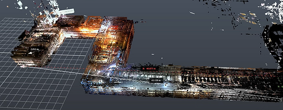
LiDAR & Point Cloud Scanning
High-resolution, accurate 3D models of buildings and sites for detailed analysis and planning.
-
Photogrammetry Scans
High-quality imagery turned into precise 3D models to capture existing conditions efficiently.
-
Drone-Based Data Collection
Aerial surveys using drones for large-scale site or building data.
-
Platforms & Systems
Utilizing tools like Cupix, Sensori, OpenSpace and DroneDeploy for streamlined data processing and visualization.
-
Applications
Supporting construction logistics, renovation planning, retrofits, real-time site monitoring, and asset management.